Cooney Tomb and Cemetery, Catron County, New Mexico
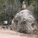
Cooney Tomb and Cemetery, Catron County, New Mexico
| Cemetery: | Cooney Tomb and Cemetery |
| GPS: | N 33.41331 W 108.83777 |
| County: | Catron |
| Directions: | From just S of the Alma Store in Alma on US 180, E approximately 4.8 mi on Mineral Creek Rd (which becomes McKean), SE side. |
Curtis Family Gravesite, Catron County, New Mexico
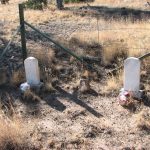
Curtis Family Gravesite, Catron County, New Mexico
| Cemetery: | Curtis Family Gravesite |
| GPS: | N 34.33458 W 108.56252 |
| County: | Catron |
| Directions: | 1.8 mi W of Quemado to US 60/NM601 junction, then continue W on US 60 2.3 mi; cemetery on S side of highway at Strang Rd. |
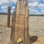
Divide Cemetery, Catron County, New Mexico
| Cemetery: | Divide Cemetery |
| GPS: | N 34.19363 W 108.16660 |
| County: | Catron |
| Directions: | From the west end of Pietown, S 6.2 mi on Double Bar Rd to Ed Jones Rd going W. Continue S on what now Green Gap Rd 1.5 mi to unnamed Rd going W; W 1.7 mi to cemetery, NE side. |
Freeman Mountain Site, Catron County, New Mexico
| Cemetery: | Freeman Mountain Site |
| GPS: | N 33.90718 W 108.77554 |
| County: | Catron |
| Directions: | 6.6 mi SW of Apache Creek on NM 12 to Forest Rd (FR) 49; Approximately 12.3 mi N on FR 49; at which point, the mountain peak to your W and 1,000 feet above you is Freeman Mountain; Grave on top. |
Gallo Canyon site at Gallita Springs, Catron County, New Mexico
| Cemetery: | Gallo Canyon site |
| GPS: | N 34.03445 W 108.57012 |
| County: | Catron |
| Directions: | N of NM 12 at Apache Creek on NM 32; N from Jewett Mesa Airstrip about 1.5 mi to Forest Road (FR) 93 going E; E 6.2 mi on FR 93 to Gallito Springs. Exact location of cemetery not known. |
Horse Springs Bible Church Cemetery, Catron County, New Mexico
Grave of Raymond G. Hoyer in the Horse Springs Bible Church Cemetery, Catron County, New Mexico
| Cemetery: | Horse Springs Bible Church Cemetery |
| GPS: | N 33.91555 W 108.33425 |
| County: | Catron |
| Directions: | 9.35 mi W of Horse Springs on NM 12; 0.3 mi W of County Road NM 93 (Mangas Rd) going N. N side, NW of church building. |
Rito Ranch Cemetery, Catron County, New Mexico
| Cemetery: | Rito Ranch Cemetery |
| GPS: | N 34.33149 W 108.40189 |
| County: | Catron |
| Directions: | W 14 mi from Pietown on US 60 to Omega (Omega Road going N); N 0.8 mi on Omega Road to road going SW; SW, W and S 2 mi to area of gravesite. Exact location not known. |
White Rock Canyon Cemetery, Catron County, New Mexico
| Cemetery: | White Rock Canyon Cemetery |
| GPS: | N 33.96724 W 108.18783 |
| County: | Catron |
| Directions: | SW from Datil on NM 12 approximately 25.9 mi to New Horse Springs; N on Horse Springs Road 0.6 mi; NW and N on dirt road 1.8 mi; NE 0.7 mi; cemetery set back on NW side. |
What’s New?
Jewett Gap Cemetery, Catron County, New Mexico
This is information about Jewett Gap Cemetery in Catron County, New Mexico.
Luna Cemetery, Luna, Catron County, New Mexico
This is a list of 22 burials occurring at the Luna Cemetery in Luna, Catron County, New Mexico.
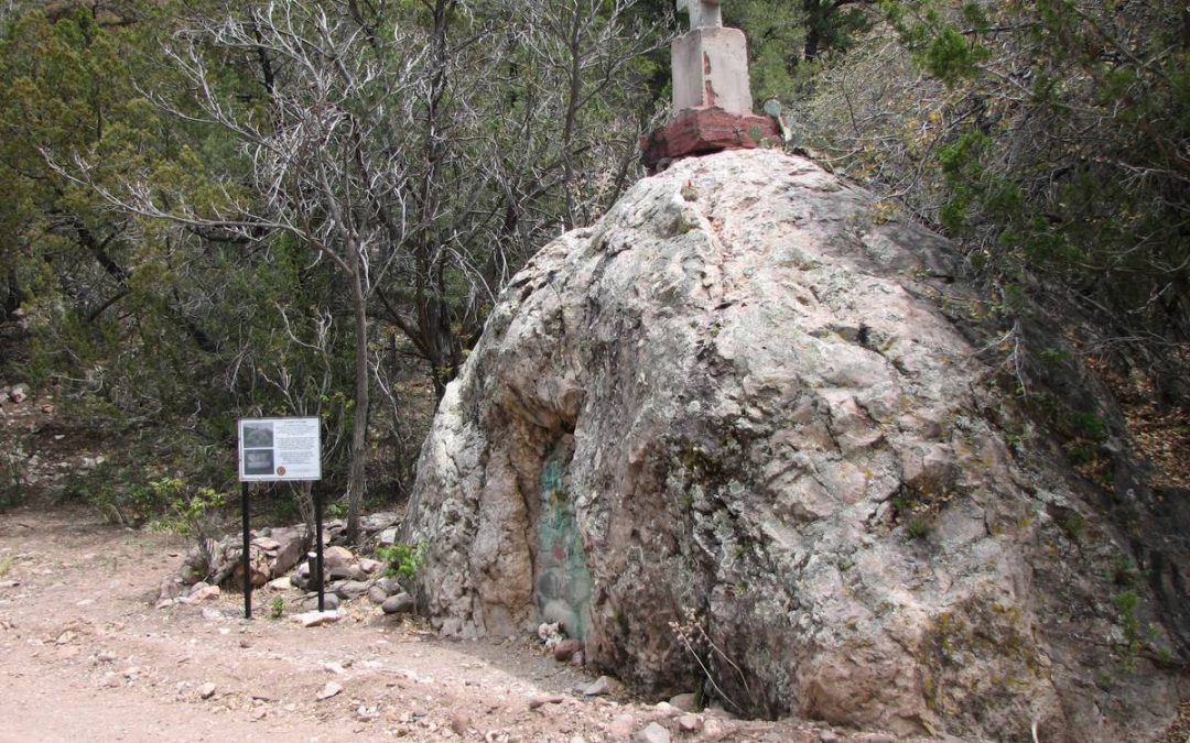
Cooney Tomb and Cemetery, Catron County, New Mexico
On April 29, 1880, Sergeant Cooney, Jack Chick, and a man whose last name was Buhlman were on horseback riding to Alma to warn the settlers of an Indian attack at the Cooney mine and the town of Cooney. Victorio had led a group of Chiricahua Apache tribal members in the massacre. Shortly thereafter, Sergeant Cooney’s brother Michael and miners from nearby Pinos Altos drilled, blasted and chipped a sepulcher for his remains in a large boulder. The Sergeant has remained interred there since. The following is a list of 7 burials occurring at the Cooney Tomb and Cemetery in Catron County, New Mexico.

Curtis Family Gravesite, Catron County, New Mexico
The following is a list of 2 burials occurring at the Curtis Family Gravesite in Catron County, New Mexico.
Divide Cemetery, Catron County, New Mexico
The following is a list of 6 burials occurring at the Divide Cemetery in Catron County, New Mexico.
Catron County is the largest county, by area, in New Mexico. Catron County’s lands were part of Socorro County from the creation of Santa Fé de Nuevo México until 1921. Before that point the county had a history indicative of many places in the Wild West, replete with gunfights, shootouts, massacres, and gold mines. At that split in 1921, Catron county was named for Thomas B. Catron, a leading figure in New Mexico statehood and its first senator. In 1927, the State Legislature attempted to abolish both Socorro and Catron in order to create a new Rio Grande County. A court suit voided this act and the two counties retained their independence. In Catron County there is a volcanic area that until recently contained sufficient heat to cause steam to rise after a slight rain. It is called Burning Mountain and appears to have been used by the Apache for healing purposes. The county is home to the Red Hill Volcanic Field as well as the Plains of San Agustin.
Alphabetical List of Cemeteries in Catron County
- A.A.C. Baca Grave Site, Quemado, Catron County, New Mexico
- Alma Cemetery, Alma, Catron County, New Mexico
- Aragon Cemetery, Catron County, New Mexico
- Balke Creek Grave, Catron County, New Mexico
- Cooney Tomb and Cemetery, Catron County, New Mexico
- Curtis Family Gravesite, Catron County, New Mexico
- Divide Cemetery, Catron County, New Mexico
- Freeman Mountain Site, Catron County, New Mexico
- Gallo Canyon site at Gallita Springs, Catron County, New Mexico
- Glenwood Cemetery, Glenwood, Catron County, New Mexico
- Greens Gap Cemetery, Catron County, New Mexico
- Greer Cemetery, Catron County, New Mexico
- Horse Springs Bible Church Cemetery, Catron County, New Mexico
- Jewett Gap Cemetery, Catron County, New Mexico
- Johnson Cemetery, Catron County, New Mexico
- Juniper Haven Cemetery, Pie Town, Catron County, New Mexico
- Leyba Cemetery, Mangas, Catron County, New Mexico
- Luna Cemetery, Luna, Catron County, New Mexico
- Quemado Community Cemetery, Quemado, Catron County, New Mexico
- Reserve Cemetery, Reserve, Catron County, New Mexico
- Rito Ranch Cemetery, Catron County, New Mexico
- Sacred Heart Cemetery, Quemado, Catron County, New Mexico
- Saint Francis Cemetery, San Francisco Plaza, Catron County, New Mexico
- Saint Isidro Mission Cemetery, Lower San Francisco Plaza, Catron County, New Mexico
- White Rock Canyon Cemetery, Catron County, New Mexico
Old Cemetery List
Being caught in transition, unfortunately, temporarily brings with it 2 different methods of finding a grave. The list above are cemeteries which have been added to the new website, while the cemeteries in the list below are those that have not yet been transferred to this website. As we move the cemeteries over to the newer format, they will disappear below and appear above.
Note that the cemeteries in the list below are not searchable using the search for the website!
| Apache Creek |
| Big Dry Creek |
| Carrejo Ranch |
| Catron Co. Miscellaneous Burials |
| Cleveland Ranch |
| Datil |
| Forest Hill aka Taylor Cemetery |
| Horse Springs Private Cemetery |
| Horse Springs Public Cemetery |
| Jewett Gap |
| Mangas (New) |
| Ranch lands and Private Graves |
| Seventh Day Adventist |
| Sunny Slope |
| Tres Lagunas |
| W.S. Ranch aka Soldiers Cemetery |
| Williams Ranch |

Recent Comments