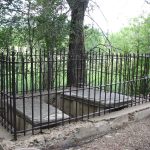
Abreu Cemetery, Rayado, Colfax County, New Mexico

Abreu Cemetery, Rayado, Colfax County, New Mexico
| Cemetery: | Abreu Cemetery |
| GPS: | N 36.36584 W 104.93351 |
| County: | Colfax |
| Directions: | From Cimarron, head S about 11 mi on NM 21 to Rayado. After crossing Rayado Creek, W about 0.5 mi on first road; S and W to cemetery. |
Aragon Family Cemetery, Colfax County, New Mexico
| Cemetery: | Aragon Family Cemetery |
| GPS: | N 36.29999 W 105.05179 |
| County: | Colfax |
| Directions: | At the mouth of Martinez Canyon. NW about 4 mi on NM 120 from Ocate to Canal Bon Road (Can Bon Rd) going N; N on Canal Bon Road 4.3 mi to Whites Peak Road; E on Whites Peak Road 2.2 mi to Y; left at Y; N on this road about 3.3 mi to Y; N at Y and follow road along Banderitas Creek approximately 3 mi to Y, where the creek goes W and the road turns E; continue 1 mi to cemetery, N side. |
Aurora Catholic Cemetery, Moras Creek, Colfax County, New Mexico
| Cemetery: | Aurora Catholic Cemetery |
| GPS: | N 36.32865 W 105.04179 |
| County: | Colfax |
| Directions: | NW about 4 mi on NM 120 from Ocate to Canal Bon Road (Can Bon Rd) going N; N on Canal Bon Road 4.3 mi to Whites Peak Road; E on Whites Peak Road 2.2 mi to Y; left at Y; N on this road about 3.3 mi to Y; N at Y and follow road along Banderitas Creek approximately 3 mi to Y, where the creek goes W and the road turns E; E 1.3 mi to road going N; N 2.4 mi to cemetery. |
Clifton House Site Cemetery, Raton, New Mexico
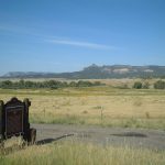
Clifton House site marker
| Cemetery: | Clifton House Site Cemetery |
| GPS: | N 36.81568 W 104.45428 |
| County: | Colfax |
| Directions: | S of Raton, W of Exit 446; N of US 64. |
Heck Cemetery, Colfax County, New Mexico
Heck Cemetery, Colfax County, New Mexico
| Cemetery: | Heck Cemetery |
| GPS: | N 36.47142 W 104.98194 |
| County: | Colfax |
| Directions: | From Caballo Rd at the Philmont Scout Ranch on NM 21, N 1.3mi on NM 21 to Cito Rd going W; W on Cito Rd 2.5 mi; small cemetery on S side, set back from road. |
Maxwell Plaza Cemetery and Memorials, Cimarron, Colfax County, New Mexico
Maxwell Plaza Cemetery and Memorials, Cimarron, Colfax County, New Mexico
| Cemetery: | Maxwell Plaza Cemetery and Memorials |
| GPS: | N 36.50564 W 104.91894 |
| County: | Colfax |
| Directions: | Exit 426 from I-25, W on Maxwell Ave, S on 3rd St past water tanks on right, W on dirt track; cemetery just beyond cattle guard, N side. |
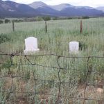
Rayado Cemetery, Rayado, Colfax County, New Mexico

Rayado Cemetery, Rayado, Colfax County, New Mexico
| Cemetery: | Rayado Cemetery |
| GPS: | N 36.36479 W 104.93393 |
| County: | Colfax |
| Directions: | S of Philmont Scout Ranch on NM 21 to Kit Carson Museum at Rayado on W side; Walk 0.2 mi W of Kit Carson Museum to Abreu Cemetery; walk S 0.1 mi to Rayado Cemetery. |
Tinaja Cemetery, Colfax County, New Mexico
| Cemetery: | Tinaja Cemetery |
| GPS: | N 36.64817 W 104.38781 |
| County: | Colfax |
| Directions: | I-25 Exit 435; 2.3 mi E and SE on County Rd (CR) A9 to intersection; continue S 0.5 mi on CR A9 to Tinaja Rd; E, SE and NE approximately 6 mi on Tinaja Rd; NE on unmarked road to cemetery. |
Valdez Cemetery, Colfax County, New Mexico
| Cemetery: | Valdez Cemetery |
| GPS: | N 36.36111 W 104.86217 |
| County: | Colfax |
| Directions: | From the Kit Carson Museum S of Rayado on NM 21, S 2.5 mi on NM 21 to intersection where NM 199 goes straight ahead and NM 21 turns E; E 4 mi on NM 21 to County Rd (CR) C6; N 0.7 mi on CR C6 to intersection; cemetery is just W of intersection on N side. |
What’s New?

Maxwell Plaza Cemetery and Memorials, Cimarron, Colfax County, New Mexico
The following is a list of 2 burials occurring in Maxwell Plaza Cemetery and Memorials in Cimarron, Colfax County, New Mexico. It also contains a family tree of Lucien Bonaparte Maxwell and Ana (Odele) Maria Luz Beaubein.
Aurora Catholic Cemetery, Moras Creek, Colfax County, New Mexico
The following is a list of 78 burials occurring in Aurora Catholic Cemetery in Moras Creek, Colfax County, New Mexico.
Valdez Cemetery, Colfax County, New Mexico
The following is a list of 5 burials occurring in Valdez Cemetery in Colfax County, New Mexico.
Tinaja Cemetery, Colfax County, New Mexico
The following is a list of 21 burials occurring in Tinaja Cemetery in Colfax County, New Mexico.

Heck Cemetery, Colfax County, New Mexico (on Philmont Boy Scout Ranch)
The following is a list of 2 burials occurring in Heck Cemetery on Philmont Boy Scout Ranch in Colfax County, New Mexico.
Colfax County was originally part of Taos County, one of the original nine counties created by the New Mexico Territory in 1852. In 1859, the eastern part of Taos County, including all of the territory of Colfax County, was split off to form Mora County. Colfax County was established on January 25, 1869 from the northern part of Mora County. The original county seat was the gold mining town of Elizabethtown.
The eastern portions of Colfax, Mora, and San Miguel counties were severed to form Union County in 1893.
Alphabetical List of Cemeteries in Colfax County
- Abreu Cemetery, Rayado, Colfax County, New Mexico
- Aragon Family Cemetery, Colfax County, New Mexico
- Aurora Catholic Cemetery, Moras Creek, Colfax County, New Mexico
- Black Lake Cemetery, Colfax County, New Mexico
- Clifton House Site Cemetery, Raton, New Mexico
- Colmor Cemetery, Colmor, Colfax County, New Mexico
- Elizabethtown Cemetery, Elizabethtown, Colfax County, New Mexico
- Heck Cemetery, Colfax County, New Mexico (on Philmont Boy Scout Ranch)
- Maxwell Plaza Cemetery and Memorials, Cimarron, Colfax County, New Mexico
- Rayado Cemetery, Rayado, Colfax County, New Mexico
- Tinaja Cemetery, Colfax County, New Mexico
- Valdez Cemetery, Colfax County, New Mexico
Old Cemetery List
Being caught in transition, unfortunately, temporarily brings with it 2 different methods of finding a grave. The list above are cemeteries which have been added to the new website, while the cemeteries in the list below are those that have not yet been transferred to this website. As we move the cemeteries over to the newer format, they will disappear below and appear above.
Note that the cemeteries in the list below are not searchable using the search for the website!
| Abbott aka Abbott North |
| Brilliant aka Swastika |
| Martinez or Abreu Cemetery aka Rayado |
| Black Lake |
| Colmor |
| Dawson |
| Elizabethtown |
| Espinoza |
| Fairmont aka Second Spanish Presbyterian |
| Fairview aka Old Raton aka Raton |
| Gallagher |
| Johnson Mesa aka Saint John’s Methodist |
| Johnson aka Sauz Creek |
| Kaplan |
| Kelleher aka Trincherita |
| Livingston aka Ring Place |
| Maxwell |
| Mount Calvary |
| Mountain View (Cimarron) aka Cimarron |
| Mountainview (Capulin) |
| Pacheco |
| Ponil Park aka Seally Canyon |
| San Antonio Catholic Churchyard |
| Springer |
| Sweetwater aka Agua Dulce |
| Sweetwater West |
| United Church of Angel Fire aka Angel Fire |
| Van Houton aka Willow Coal Mine |
| Vietnam Veterans Memorial State Park Cemetery |

Recent Comments